For too many of us, land is defined by its political borders. People usually identify locations by their country, state, or province. Or we often define regions by their cultural environment – think the Rust Belt, Bible Belt, or Corn Belt. But rarely do we think about geography in terms of bioregions. What is a bioregion? A bioregion is geographic area that is defined by natural features like common species assemblages, watersheds, or terrain. This concept overlaps with terms like ecoregions and physical geography. It also overlaps with cultural geography. It’s important to recognize that borders are largely a cultural construct, and that most of the bioregions mapped here don’t really have precise borders – just gradients.
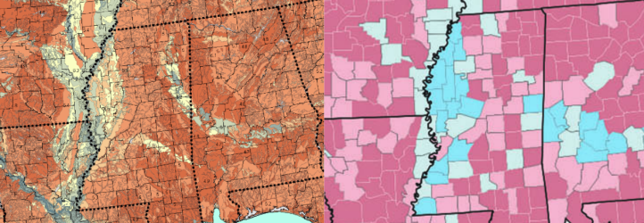
Because of the inseparable connection that humans have with nature, bioregions play a significant role in the functioning of human societies. Take the following example:
The soil pH map on the left shows the more alkaline soils of the Mississippi Alluvial Plain and the Black Belt surrounded by acidic (red) soils. Note that the Black Belt, while predominantly African-American, was originally named for its black topsoil and not its demographics, and is not to be confused with the much broader cultural region also called the Black Belt. Compare this to the map on the right of the 2016 US presidential election in which most of Mississippi and Alabama voted Republican with the exception of the Alluvial Plain and the Black Belt. Nature shapes who we are, and where and how we live our lives.
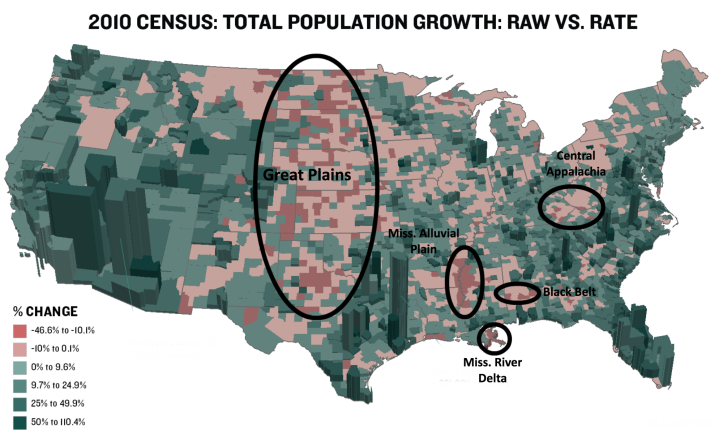
Here’s another example of how bioregions intersect with culture and the built environment. In the above map of population change in the US, the areas that experienced the largest population losses were all marginalized bioregions such as the Great Plains, Central Appalachia, the Mississippi Alluvial Plain, Black Belt, and Mississippi River Delta.
Bioregionalism, the movement to identify with one’s bioregion and live sustainably within it, is only mere decades old in its modern iteration. But bioregionalism is not a new concept, considering that indigenous peoples around the world have understood this throughout history. For those familiar with the Decolonial Atlas, you know that we are big advocates of using indigenous place-names whenever possible. Perhaps one day we will create a more decolonized version of this map with indigenous names for these bioregions, but until then…
Bioregions of North America map by Jordan Engel can be reused under the Decolonial Media License 0.1. We’d love to see photos of this map in use!
This map uses the Lambert Conformal Conic projection, and was adapted from Mapswire.
For more resources, check out:
The EPA’s level III and IV US ecoregions maps.
Ecozones and Ecoregions of Canada map.


Greetings. I live in Montana, land of the Rockies and ancestral lands of many indigenous nations. However, I have lived in Guatemala and Venezuela plus a large part of my life in Texas on the Gulf. When I first saw the map posted my heart opened. The oneness of it all. The connectedness of mountain ranges and of course the people, the other animals, the birds, the insects etc. I hope humanity will embrace the concept of no borders at some point.
LikeLike
Many ppl would love to know when and where we can obtain this valuable information. Please inform soon. Much appreciated
LikeLike
[…] https://decolonialatlas.wordpress.com/2017/10/25/bioregions-of-north-america/ […]
LikeLike
Would it be possible to purchase maps?
LikeLike
Great! Quebec have already do a lot of work on this and a lot of maps. The territory is organised along the line of the presence of a river, and the bioregion, so… By exemple, my civic adresse is «10e Rang », which means you count 10 roads (or 10 farming lot) from my house to the St-François River, the river who define my local bioregion (see Politique des Bassins versants). Every municipality know in which bioregion she live. Every bioregion have a local-state institution who include special seat for Native… mine is http://cogesaf.qc.ca/ It’s far from perfects, but it’s very good. Infortunely, for now, it does’t have penetrate symbolic politic. (First time i write something in english… sorry).
LikeLike
What are the other major peninsulas and islands called, and more importantly, how did indigenous peoples refer to them? There is strong potential in that for the renaming of some states and provinces, names which are far less makeshift, far more fitting, and far more accurate in the scheme of things.
LikeLike
Think bioregional assessment and solutions for that region’s carbon footprint.
LikeLike
[…] of your area? What landforms (hills, rivers, gorges, lakes, mountains) are there around you? What bioregion do you live […]
LikeLike
[…] of your area? What landforms (hills, rivers, gorges, lakes, mountains) are there around you? What bioregion do you live […]
LikeLike