For the native nations living along the US-Mexico border, the border is a barbed wire fence through their living room. Over the course of generations, they’ve formed connections on both sides of the border, and yet they’re considered foreigners and illegal immigrants in their ancestral homelands. In the O’odham language, there is no word for “state citizenship.” No human being is illegal.
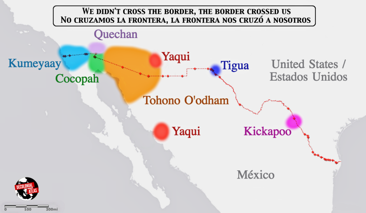
In this map, the territories of the Kumeyaay, Cocopah, Quechan, Tohono O’odham, Yaqui, Tigua, and Kickapoo are shown straddling the 2,000 mile border, with the red dots along the border representing official border crossings.
The Tribes Spanning the US-Mexico Border map by Jordan Engel can be reused under the Decolonial Media License 0.1.
Para los pueblos indígenas que viven por la frontera entre los Estados Unidos y México, la frontera es una pared en medio de su sala. Por generaciones, han formado conexiones en los dos lados de la frontera, y sin embargo se los consideran extranjeros y inmigrantes ilegales en su propia patria. En la lengua O’odham, no hay una palabra para “ciudadanía estatal”. Ningún ser humano es ilegal.
En este mapa, los puntos rojos representan los cruces fronterizos oficiales. Muestra los territorios de los Kumiai, Cucapá, Quechan, Tohono O’odham, Yaqui, Tigua, y Kikapú.


[…] https://decolonialatlas.wordpress.com/2017/03/21/the-border-la-frontera/ […]
LikeLike
Wonderful internet site you have in this article, i do agree on some issues however, but not all.
LikeLike
you’re missing the Lipan Apache
LikeLike
I appreciate there is an attempt to represent Indigenous tribes. This map isn’t representing the current-day reality lived on the ground. What this map conveys is the dominant, US, euro-centric view of indigenieity in and along the US-MX bordered and walled region which is a dynamic in constant contestation against state-driven political ideology and tribalisms (political entities highly susceptible to the ‘threat’ of resurgent indigeneities which are at play outside the state’s recognition regimes). The current-day lived, experienced and understood Indigenous World of the bordered-walled territories are erased here. So my question is–rather than decolonial, isn’t this a perpetuation of the colonial hegemonic establishment and ‘authorized’ cartographies which re-endow the state with power to name and shape realities for social, political and economic purposes which serve powerful interest groups? Given the title of this website, “decolonial atlas”, this map isn’t offering a decolonial understanding in lived experience, space, and time. Meaning, these tribal groupings are normative representations based upon a US nation-state centered ideological and mythical view — frought with censorship — a normed standard which intentionally ignores the ‘non-status’/non-recognized Indigenous nations, governments, tribes, and polities in the bordered region and these political struggles for visibility and alternative recognition beyond the settler colonial nation-state. US federally recognized ‘Indian’ nations are only a slice of the larger whole of the US-MX region when it comes to the diversity of continuing, surviving, and self-determining Indigenous peoples, nations, and tribes. To address this current-day political reality in cartographic ‘truth’s –from Indigenous peoples’ social organizations–would be an enriching and educating enactment of decolonial mapping. I hope this map continues to grow into the ‘decolonial’.
LikeLike
…and this doesn’t even take into consideration the border movement that occurred – more than once – in the 1800s.
LikeLike